Monday, November 07, 2016

Linac 4 reached its energy goal | CERN


Linac 4 reached its energy goal

CERN's new linear accelerator (Linac 4) has now accelerated a beam up to its design energy, 160 MeV. This important milestone of the accelerator's commissioning phase took place on  25 October.

Linac 4 is scheduled to become the source of proton beams for the CERN accelerator complex, including the Large Hadron Collider (LHC) after the long shutdown in 2019-2020. It will replace the existing Linac 2 as the first link in the accelerator chain, which is currently accelerating protons at 50 MeV. The new 30-metre-long accelerator will accelerate hydrogen ions – protons surrounded by two electrons – at 160 MeV, before sending them to the Proton Synchrotron Booster. Here, the ions are stripped of their two electrons to leave only the protons that will be further accelerated before finishing their race in the LHC.

Linac 4 comprises four types of accelerating structures to bring particles in several stages to higher and higher energies. These accelerating structures have been commissioned one by one: in November 2013, the first hydrogen ion beam was accelerated to the energy of 3 MeV and two years after, the Linac 4 accelerator has reached an energy of 50 MeV – the energy Linac 2 runs at. Then, on the 1 July 2016, it crossed the 100 MeV threshold.

~A.

Disasters waiting to happen: 8 most dangerous nuclear plants near earthquake fault lines — RT News

Disasters waiting to happen: 8 most dangerous nuclear plants near earthquake fault lines — RT News

Disasters waiting to happen: 8 most dangerous nuclear plants near earthquake fault lines

The Japanese government says there won't be any catastrophic damage, this time, at its nuclear facilities following Thursday night's devastating earthquake and subsequent aftershocks.

Nine people are confirmed dead and more than 1,000 others injured after a 6.5-magnitude quake hit east of the city of Kumamoto.

The disaster revived terrifying memories of the Fukushima disaster, when a 15-meter post-quake tsunami caused a nuclear meltdown that polluted a sizeable portion of the country for decades.

Japan's Chief Cabinet Secretary Yoshihide Suga confirmed that there were no abnormalities at any nuclear facilities in the area, the Japan Times reported.

Despite the 'all clear', dozens of potential atomic bombs operate along seismic fault lines. Here are eight of the most deadly, including one that may never be built because of Fukushima.

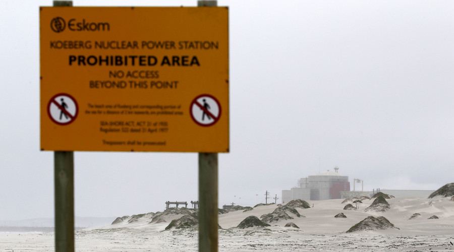
Koeberg nuclear power plant, Capetown

Signs prohibit entry to South Africa's Koeberg nuclear power plant near Cape Town. © Mike Hutchings

Koeberg is the only nuclear power plant on the continent of Africa and just 8km from the Milnerton fault, which crosses Table Bay.

While the largest earthquake to hit the city came more than 200 years ago, the Milnerton fault has the potential to hit at least 6.5 on the Richter scale.

Energy company Eskom have insisted the plant is built to "ensure that no radiation escapes under any conceivable circumstances, from an earthquake to a jumbo jet collision."

Diablo Canyon Power Plant, California

Situated along by the shores of the Pacific Ocean - and four active fault lines, this plant has come under scrutiny since Fukushima.

Diablo Canyon's two reactors lie in an earthquake red zone with the Hosgri fault, the Los Osos fault, the San Luis Bay fault, and the Shoreline fault all nearby - and the major San Andreas fault 80km away.

Operators PG&E say the plant has been upgraded to withstand a 7.5 magnitude earthquake and a 2011 report cited sensitivity tests that suggest the area was "very unlikely"to experience quakes larger than 7.1.

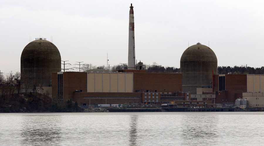
Indian Point, New York

The Indian Point nuclear power plant in Buchanan, New York, is seen from across the Hudson River. © Mike Segar

The Empire State's Indian Point is considered by many to be the next Fukushima.

Not only has the plant been plagued with operational problems, but it is situated almost on top of the Rampano fault line.

A study by Columbia University in 2008 suggested the New York area was at greater risk of high-magnitude earthquakes than first thought, with the discovery of a new potential disaster area, the Stamfrod-Peekskill line.

A spill of radioactive water at the plant in January led environmentalists to call for its closure, with the Riverkeeper group declaring that the site, which runs reactors from the 1970s, "isn't safe anyone."

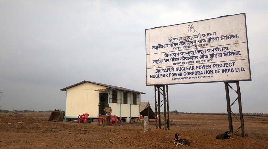
Jaitapur Nuclear Power Project, India

A policeman stands at a kiosk at the proposed site of the Jaitapur nuclear plant in Ratnagiri district, about 360 km (224 miles) south of Mumbai. © Danish Siddiqui

The French company Areva NP are proposing to build one of the largest nuclear plants in the world in India, capable of producing 9900 MW of power.

Greenpeace is among those opposing the six reactor plant, questioning the safety of its pressurized water cooling system and the shaky ground on which it might be built.

Like Fukushima Daiichi, Jaitapur would be operate along by the sea. Critics say the 16 fault lines on the west coast pose a serious threat to safety. However, India's Atomic Energy Regulatory Board are satisfied that there are no faults within 5km.

Columbia Generating Station, Washington state

The last nuclear power plant remaining in the Pacific Northwest, the Columbia Generating Station (CGS) could be a potential disaster because of its Fukushima-like boiling water reactor.

It's located near the Columbia river along the Cascadia subduction zone, acknowledged by the Washington State Department as capable of producing "some of the largest and most damaging earthquakes in the world."

A 2013 Seattle Times report quoted a geologist working with the Physicians for Social Responsibility as saying the plant had not undergone structural upgrades since its opening in 1984. A March 2015 risk assessment stated that seismic damage to the site "is low for CGS."

Arkansas Nuclear One, Arkansas

A study of the US Geological Survey hazard map suggests the Arkansas state nuclear plant could be at risk from the New Madrid zone, one of North America's most active areas for earthquakes.

A quake in 1811 was thought to be 8.0 on the Richter scale and reportedly rang bells over a thousand miles away in Boston. The US government warns the damage to the area is likely to be 20 times larger than a "big one" in California due to the "less fractured nature" of the rock.

Following the Fukushima disaster, Arkansas plant operators Entergy issued a statement detailing the improvements it was making to ensure nuclear safety.

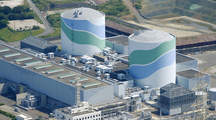
Sendai Nuclear Power Station, Japan

An aerial view shows the No.1 (L) and No.2 reactor buildings at Kyushu Electric Power's Sendai nuclear power station in Satsumasendai, Kagoshima prefecture, Japan. © Kyodo

Sendai is currently the only nuclear power plant currently operational in Japan after the country's other 50 reactors were shut down following the Fukushima meltdown.

The plant was reopened in 2013 after a two-year break from nuclear energy. A report by the Japanese Nuclear Regulation Authority found the site safe to restart after upgrades of more than $100 million to meltdown systems and disaster response.

Sendai and other Japanese power plants need to withstand their precarious position near the tectonic plate zone called the Japan Trench. Because of plate movements in this area, the Pacific country is hit by an estimated 1,500 earthquakes per year.

Akkuyu Nuclear Plant, Turkey

The US$20-billion Akkuyu Nuclear Power Plant in Turkey slated to go up along the Mediterranean coast is a joint project with Rosatom.

Foundations for the four reactor facility were laid in April last year despite opposition to its location, which is approximately 25km from the Ecemis fault line.

The Republic of Cyprus expressed its concern with the plans when Energy Minister Antonis Paschalides questioned the decision to construct it in "a seismically active area."


~A.

Earthquake Risk | San Onofre Safety

Earthquake Risk | San Onofre Safety

Earthquake Risk

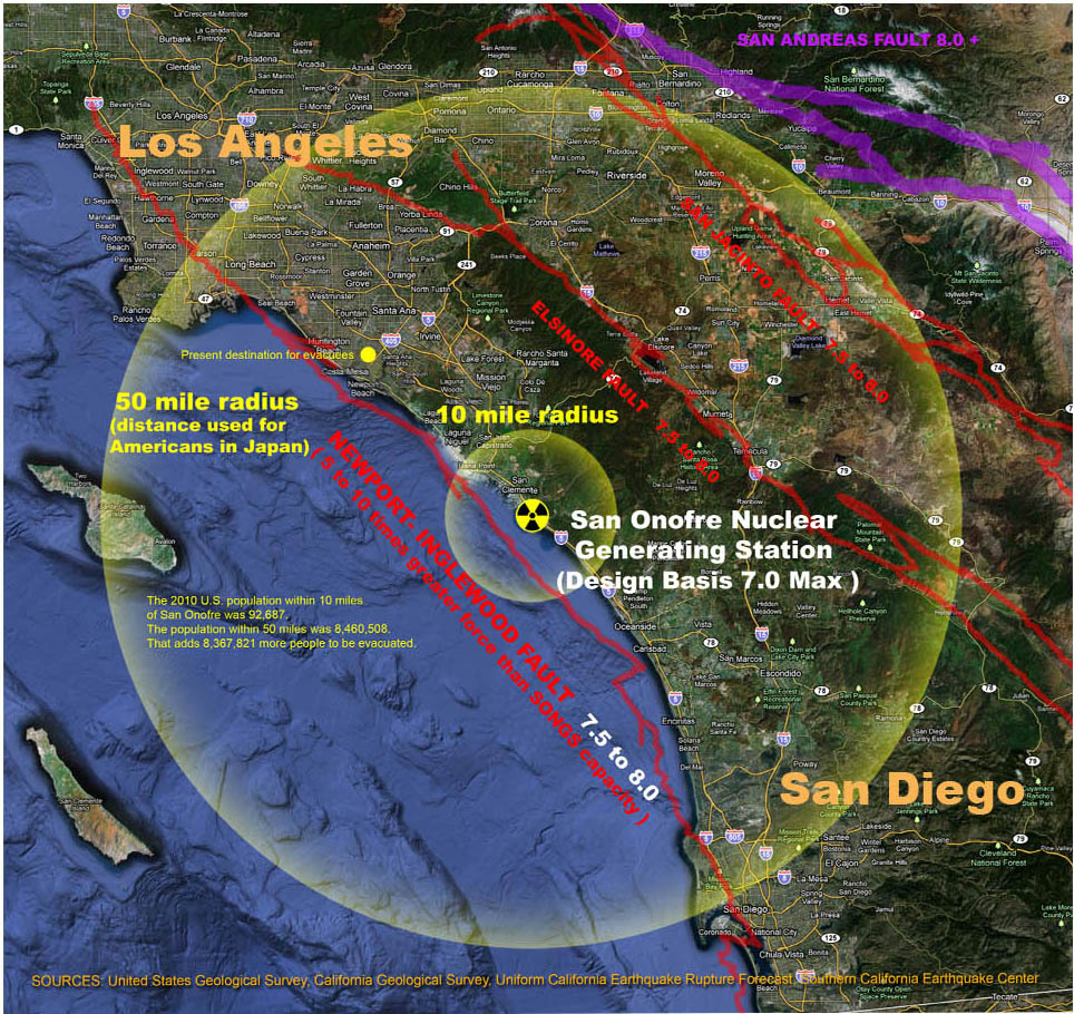
Earthquake Map within 10/50 miles of San Onofre San Onofre was redesigned for a 7.0 earthquake, but sits near faults capable of 8.0+ earthquakes 10 times larger, 32 times stronger, and long overdueSee USGS earthquake calculator.

USGS predicts probability of at 7.5+ earthquake in Southern California as 36% in 30-years and a probability of a 7.0+ earthquake as 75%. Northern California a 7.0+ as 37% in 30-years.

There is no seismic rating for the nuclear waste thin storage canisters that may already be cracking at San Onofre and other nuclear plants, especially in the corrosive coastal environment. Each of the canisters contains more radiation (Cesium-137) than that released from Chernobyl.

Nelson Mar, PhD (former Senior Engineer for the original design of San Onofre Units 2 & 3), said San Onofre is not designed for current earthquake or tsunami risks. See 3/27/12 Irvine City Council meeting video.

Over the next 30 years the probability of a major earthquake occurring in Southern California is 60% and 67% in the San Francisco Bay area.

USGS: "...no scientists have EVER predicted a major earthquake."

USGS M5+ earthquakes

5.5+ magnitude. Source: USGS Centennial Catalog 1900 – 2002 and USGS/NEIC (PDE) Catalog 1973 – Feb 2014

They do not know how and they do not expect to know how any time in the foreseeable future.   Major earthquakes can occur on what are predicted to be minor faults. Based on scientific data, only probabilities can be calculated for potential future earthquakes. U.S. Geological Survey (USGS)

Many seismic countries, however, have research programs based on identifying possible precursors to major earthquakes. This includes the study of dilatancy, how rocks crack and expand under the increased stress associated with the earthquake. Some major earthquakes, but not all, are heralded by the occurrence of foreshocks. which can be detected by dense local monitoring networks. Other instruments can measure changes in the levels of radon gas, electrical and magnetic properties, velocity changes of seismic waves and changes in topography. Long term monitoring and examination by these sensors is required as some or all of these factors may change due to the opening of cracks PRIOR to the earthquake. All attempts to predict earthquakes have, however, been generally considered as failures and it is unlikely that accurate prediction will occur in the near future.  Efforts will, instead, be channelled into hazard mitigation. Earthquakes are difficult or impossible to predict because of their inherent random element and their near-chaotic behaviour.  British Geology Survey FAQS

    • "The Earth's natural systems are not static… This is why I personally feel we need to regularly update the scientific data we use to inform our regulatory approach so that our nuclear facilities are adequately protected against unanticipated events", said NRC Chairman Macfarlane at the November 6, 2012 INPO CEO conference, in reference to the Fukushima nuclear disaster.

Building design limitations due to ground motion unpredictibility

Professor Thomas Heaton of Caltech's Earthquake Engineering Research Lab, reveals limitations in designing structures to protect against large earthquakes. Every earthquake has different dynamics and affects different types of construction differently.  "All tall buildings are designed to be flexible, but here's the rub," Heaton said. "People talk about a building designed for an 8 [magnitude], as if anybody has a good idea of what the actual ground motion would be in an 8. There's tremendous variation from one place to another." If you "put a really large quake under downtown L.A., 7-plus, it could be a true nightmare." L.A. Times, Earthquakes on the brain, April 1, 2014.

Disconnected faults can jump nine feet, according to new 2015 USGS data

Southern California 8+ earthquake 30-year probability increased from 3% to 7% due to new understanding about how disconnected faults can jump up to nine feet.

Estimates of the chance of a magnitude 8.0 or greater earthquake hitting California in the next three decades have been raised from about 4.7% to 7%, the U.S. Geological Survey said Tuesday [March 9, 2015].  Scientists said the reason for the increased estimate was because of the growing understanding that earthquakes aren't limited to separate faults, but can start on one fault and jump to others. The result could be multiple faults rupturing in a simultaneous mega-quake… LA Times, March 9, 2015

New Forecast for California's Earthquake Fault System,  USGS, March 2015

USGS CA Earthquake Risk 2015

Fracking on the Newport-Inglewood Fault

Los Angeles Basin Injection Wells Earthquakes Figure4-4-9Several wells in the Wilmington field are located within 4 km (2.5 mi) of the Holocene Palos Verdes fault (slip rate 3 mm/yr). Only scattered seismicity has occurred near any these fields except Inglewood and Cheviot Hills at the northwestern end of the Newport-Inglewood trend. As in the Ventura Basin, clusters of seismicity are located close to some disposal wells but also elsewhere. The cluster at the top-center of the figure are aftershocks of the 2014 La Habra earthquake.

An Independent Scientific Assessment of Well Stimulation in California, An Examination of Hydraulic Fracturing and Acid Stimulations in the Oil and Gas Industry, Jane C. S. Long, PhD, California Council on Science and Technology, Steering Committee Chairman; Science Lead Jens T. Birkholzer, PhD, Lawrence Berkeley National Laboratory Principal Investigator; Laura C. Feinstein, PhD, California Council on Science and Technology, Project Manager

Fracking can trigger earthquakes

Correlation between earthquake frequency and volume of contaminated waste injected. Rocky Mountain Arsenal Well, Colorado 1962-1965

Correlation between earthquake frequency & volume of contaminated waste injected. Rocky Mountain Arsenal Well, Colorado 1962-65

Earthquakes can be triggered by any significant perturbation of the hydrologic regime.  In areas where potentially active faults are already close to failure, the increased pore pressure resulting from fluid injection, or, alternatively, the massive extraction of fluid or gas, can induce sufficient stress and/or strain changes that, with time, can lead to sudden catastrophic failure in a major earthquake.

Source: Triggered Earthquakes and Deep Well Activities, Craig Nicholson and Robert L. Wesson, 1992.

.

  Lessons learned from the March 11, 2011 9.0 Tohoku, Japan earthquake.

    • Seismologists across the globe were surprised by the magnitude of shaking that occurred in the segment of fault responsible for the Tohoku quake. Japanese scientists had not believed a quake of such intensity could occur in that area, which in turn impacted tsunami strength estimates.
    • Insights gained from the Tohoku earthquake are leading scientists to re-evaluate the way they've assumed many other major faults are segmented. This may end up altering some hazard analyses for the West Coast, and will contribute to improved scenario modeling, building code development, and public warnings about tsunami threats.
    • An unparalleled amount of strong ground motion data were recorded.
    • Many cases of liquefaction were witnessed and filmed for the first time. Liquefaction occurs when soil loses strength and stiffness due to an applied stress like an earthquake and behaves like a liquid, often causing damage to structures and infrastructure.
    • Even though the Japanese had planned and were well-prepared for a 200- or 300-year tsunami, they were not prepared for the 1000-year tsunami (an event that's likely to occur just once every 1,000 years) that came instead. Consequently, Japan is currently updating its tsunami disaster plans for all of its coastal areas and requiring that all plans take evidence from paleo-tsunami deposits into consideration.
    • Paleo-tsunami deposits are the sand and mud that tsunamis leave behind. By studying deposits from recent events like the March 11 tsunamis, scientists are able to develop criteria for what those deposits look like and use them to examine coastal areas for records of tsunamis that struck centuries back. They can tell when tsunamis occurred and how far inland they reached by looking at the evidence left behind.  USGS coastal and marine geologists Bruce Jaffe, Bruce Richmond, and Rick Wilson have worked with Japanese scientists over the past year to study these deposits in Japan. Said Jaffe, "Japan has learned from this tsunami that it's necessary to look at the geologic evidence for tsunamis in conjunction with the current understanding of earthquake potential to accurately assess the future tsunami hazard." He explained that "Each tsunami brings its own sand and mud. Japan recognizes the value of using the very rich record of past tsunamis to help us understand the hazard for future tsunamis."
    • The United States is also conducting its own paleo-tsunami deposit studies in California, Alaska, the Caribbean, Puerto Rico, and the Virgin Islands to better understand the tsunami risk in those areas.

Ratepayers must pay $64 million in new seismic studies.

Lessons learned about strike-slip faults from 8.6 East Indian Ocean earthquake.

    • On April 11, 2012, an 8.6 earthquake struck the East Indian Ocean along a strike-slip fault – the largest earthquake ever recorded on a strike slip and 10 times larger than any previously recorded strike-slip quake.
    • A large earthquake in one part of the globe can trigger earthquakes elsewhere. In the 6 days after the quake, the number of earthquakes across the globe that were 5.5 or larger increased nearly five fold. "if you asked any of us if this event is possible a year ago, we would have laughed at you", said Thomas Heaton, seismologist at California Institute of Technology. BayCitizen.org 9/28/2012, USGS 9/26/2012, Nature 2012

San Onofre and Diablo Canyon nuclear plants are located within the "Ring of Fire".Ring of Fire

The "Ring of Fire", also called the Circum-Pacific belt, is the zone of earthquakes surrounding the Pacific Ocean. About 90% of the world's earthquakes occur there.

See animation of 2011 global 6.0+ earthquakes (using USGS data) and more maps below.

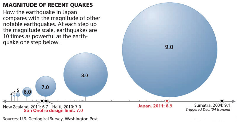
Mexico's recent 7.4 earthquake (03/20/2012) was 2.5 times larger and 4 times stronger than what San Onofre is designed for. Japan's Fukushima Daiiachi nuclear meltdown began after a 9.0 earthquake.

Lessons learned about length of a fault.

Known length of a fault is not always a predictor of magnitude as in the 1952 Kern County 7.5 earthquake.

Kern County 7.5 Earthquake 1952

Vertical fracture on the northeast side of Bear Mountain, along the White Wolf Fault. At this location, a vertical displacement of 60 cm (2 ft) and a horizontal (left-lateral) displacement of 45 cm (1.5 ft) were measured along the break. Photo: University of California, Seismographic Station

Seismic evaluations are not required before license renewal. 

San Onofre was originally licensed to shut down in 2013, but was extended to 2022. The plant was designed in 1973 for a 40 year lifespan. In 2013 Southern California Edison plans to ask for an extension to 2042. A comprehensive seismic analysis has not been conducted on San Onofre since 1995, according to an April 2012 Government Accountability Office report.

Magnitude Comparison
 

Handouts

.

Resources

Forecasting California's earthquakes – What can we expect in the next 30 years (USGS)
The Uniform California Earthquake Rupture Forecast, Version 2 (UCERF 2)
California Institute of Technology (Caltech)
Southern California Earthquake Center (SCEC)
Nuclear Regulatory Commission
LA Times "50 New California Faults" 04/28/2010
Earthquake Country Information
Kern County Earthquake 7.5 (SCEC)
Significant Earthquakes & Faults in Southern CA (SCEC)
Earthquake Facts and Statistics (USGS)
British Geological Survey FAQS
.

Maps


Map Southern California Earthquake Faults
 

Southern California 8+ earthquake 30-year probability increased from 3% to 7% due to new understanding about how disconnected faults can jump up to nine feet.  Estimates of the chance of a magnitude 8.0 or greater earthquake hitting California in the next three decades have been raised from about 4.7% to 7%, the U.S. Geological Survey said Tuesday [March 9, 2015].  Scientists said the reason for the increased estimate was because of the growing understanding that earthquakes aren't limited to separate faults, but can start on one fault and jump to others. The result could be multiple faults rupturing in a simultaneous mega-quake… LA Times, March 9, 2015

USGS A New Earthquake Forecast for California's Complex Fault System, March 2015

USGS CA Earthquake Risk 2015

USGS California Earthquake Risks, revised March 2015

California Earthquake Probabilities Map - SCEC.org

    Note: Probabilities are outdated on this map. Use 2015 data from above for probabilities


  USGS US %G Force Hazard Map

Global Earthquakes (1900-1999)

Global Earthquakes 1900-1999

Source USGS   

2011 Global 6.0+ earthquakes plotted and animated with sound

.. SONGs and Scripps Seismic Submarine
San Onofre disaster

Our worst nightmare every time the earth shakes in Southern California


~A.